Business Details
28 Years
experience
Professional Surveying and Drone Services in Chesterfield
Established in 1998, Peak Surveying Services has built a reputation for delivering precise and reliable surveying solutions across the UK. Our expertise spans topographic land surveys, drone operations, 3D modelling, and volumetric calculations, serving architects, construction firms, and land developers. Utilising cutting-edge Leica equipment and CAA-licensed drone technology, we combine technical excellence with a client-focused approach. Our team's extensive experience ensures tailored services for projects ranging from small residential developments to large-scale quarries. With nationwide coverage from our Chesterfield base, we prioritise accuracy, efficiency, and clear communication.Clients value our commitment to deadlines, competitive pricing, and the ability to handle complex requirements with professionalism. Our accreditations with Avetta, the Civil Aviation Authority, and Safety Pass Alliance underscore our adherence to industry standards. Regular investment in training and technology keeps us at the forefront of surveying innovation. We maintain equal dedication to all clients, whether large corporations or individual property owners. This consistent focus on quality has earned long-term partnerships and industry recognition.
Services
Topographic Surveys
Drone Aerial Photography
3D Modelling
Volumetric Calculations
Site Setting Out
Visual Impact Assessments
Underground Mine Surveys
Orthomosaic Mapping
Geological Cross-Sections
Project Management
Details
- Year established: 1998
Highlights and features
- We have 25+ years of experience in land surveying and drone operations
- Our team uses state-of-the-art Leica survey equipment and CAA-licensed drones
- We provide tailored solutions for both small-scale and large infrastructure projects
- Our CAA Operational Authorisation (PAndEUAS2728) ensures compliant aerial operations
- We maintain Avetta accreditation for health & safety compliance excellence
Associations and certifications
- Avetta
- Civil Aviation Authority
- Drone Pilot Academy
- Safety Pass Alliance
What people say
Professionalism, attention to detail
Highly recommend
Accurate and reliable
Competitive pricing
Excellent service
Services
Topographic Surveys
We conduct detailed topographic surveys using Leica equipment to create accurate site plans for construction and development projects. Our surveys capture terrain features, elevations, and existing structures with millimetre precision. Clients receive digital deliverables compatible with CAD and GIS software for planning and design purposes.
Drone Aerial Photography
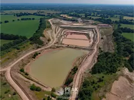
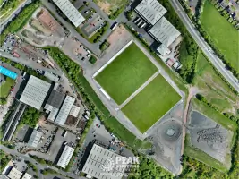
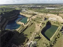
Our CAA-licensed drone operators capture high-resolution aerial photographs and 4K video for site documentation and marketing. Using photogrammetry software, we create orthomosaic maps covering large areas with georeferenced accuracy. Clients benefit from cost-effective aerial data collection compared to traditional methods.
3D Modelling
We generate detailed 3D models of landscapes and structures using survey data and drone-captured imagery. These models support visual impact assessments, construction planning, and virtual site walkthroughs. Clients use our 3D visualisations for planning applications and project presentations.
Volumetric Calculations
We perform precise volumetric calculations for quarry stockpiles and earthworks using drone data and total station measurements. Our reports include material volumes with error margins below 2%, supporting inventory management and project costing for mining and construction clients.
Visual Impact Assessments
We conduct visual impact assessments using ZVI (Zone of Visual Influence) software to determine development visibility from public viewpoints. Our reports include line-of-sight analysis and tonal maps, helping clients address planning concerns and design mitigation measures.
Questions
What surveying services do you offer?
We provide topographic surveys, 3D modelling, volumetric calculations, site setting out, and visual impact assessments using advanced survey equipment and drone technology.
Are your drone operations CAA licensed?
Yes, we hold CAA Operational Authorisation PAndEUAS2728 with DPA-C qualified pilots, ensuring full compliance with UK aviation regulations for aerial work.
How quickly can you complete a survey?
We prioritise timely delivery, typically completing standard surveys within 5-7 working days depending on site complexity and weather conditions.
Do you work nationwide?
Based in Chesterfield, we provide surveying services across the UK, supporting both local and national projects with equal dedication.
What industries do you serve?
We work with construction companies, architects, quarry operators, civil engineers, and land developers on residential, commercial, and infrastructure projects.
How do you ensure data accuracy?
We use Leica TS16 total stations with ±2mm precision and DJI M300 drones with 43MP cameras, combined with rigorous quality control processes.
Reviews (2)
Victoria Philpott
Oct 04, 2019
Report
I hired Rob and the team to survey a sloping garden plot for re-design. They were able to schedule in the work quickly and turned it around within a day, allowing me to get on with my design. Rob was friendly, professional and efficient. I'd definitely recommend them. Thanks guys!
Jim Mundy
Jun 05, 2019
Report
We use Peak Surveying for all our architectural survey requirements. I would highly recommend them. Fast service at a competitive price.